 |
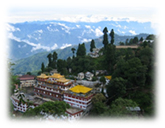
East India Hill Station
|
 |
|
|
|
|
|
|
|
East India is a land synonymous with natural beauty and cultural diversity. Blue
Mountains, lush green valleys and beautiful rivers are an integral part of this
region. Enjoy the cool climate, green landscape, clear mountain air and
beautiful meadows of the East Indian hill stations. Displaying nature in the
purest form the hill stations of East India are far away from the hustle n
bustle of city life.
|
|
|
|
|
These are some famous Hill station in Eastern India. |
|
|
Darjeeling |
|
|
Gangtok |
|
|
Kalimpong |
|
|
Shilong |
|
|
|
|
|
|
|
|
|
|
Darjeeling
|
|
Location : West Bengal |
 |
|
Darjeeling popularly known as the land of the thunderbolts is a small town in
West Bengal. The city lies in the foothills of the Himalayas and offers a
wonderful scope for eco tourism. The city covers a total area of about 3149
square km and is connected by road and rail network. Darjeeling also has its
name listed among the UNESCO World Heritage Sites for its Himalayan Railways.
Also known as the queen of the Himalayas, the city has some of the most
attractive tourist attractions which results in inflow of large number of
tourists each year to enjoy a vacation in this beautiful city in West Bengal. |
Darjeeling tea, which is one of the most exported items from the city, occupies
a place of pride in the entire world
|
|
for its fresh aroma and taste . The city is a paradise for trekkers and is one
of the most sought after cities for adventure lovers.
|
|
|
|
|
|
|
|
|
Prime Attractions
|
|
|
|
Dhoom Gompa, Darjeeling |
|
|
|
About 8 kms from Darjeeling is the Dhoom Gompa. Here a very beautiful statue of
the Maitrayie Buddha is established. The Monastery has also preserved some of
the rare handwritten Buddhist manuscripts.
|
|
|
|
|
|
|
|
The Mall: |
|
|
|
The Mall is Darjeeling's popular commercial street. It is lined with Tibetans
selling hand-knitted sweaters and souvenir shops chock-full of Himalayan
artifacts and both real and imitation antiques.
|
|
|
|
|
|
|
|
Chowrasta: |
|
|
|
The Chowrasta, meaning crossroad, is a hive of commercial activity. The Mall
Road originates and culminates at the Chowrasta. This is the heart of Victorian
Darjeeling. Here hotels, restaurants and shops brush against each other. The
shops and stalls are a veritable paradise for souvenir collectors.
|
|
|
|
|
|
|
|
Obeservatory Hill: |
|
|
|
The oldest site in Darjeeling is Observatory Hill, known locally as
“Makal-Babu-Ko-Thaan”.
|
|
|
|
|
|
|
|
Himalayan Mountaineering Institute: |
|
|
|
A spot not to be missed is the Himalayan Mountaineering Institute created by the
late Tenzing Norgay, the Sherpa who conquered Mt Everest with Sir Edmund Hillary
on 29 May 1953. A display of equipment used on the climb is one of the
highlights.
|
|
|
|
|
|
|
|
Excursions |
|
|
|
Kalimpong: This city is located near Darjeeling at an altitude of about
1250 m and has many places of tourist attractions like Kalibari, Kalimpong
market, Gouripur House, Golf Course, Pedong Monastery, and Rishyap.
|
|
|
|
|
|
|
|
Kurseong: This city near Darjeeling is located at an altitude of about
1458 m and is famous for its scenic beauty with peace and tranquility all
around. Eagle’s Crag which offers a panoramic view of the Siliguri plains and
hills is located here.
|
|
|
|
|
|
|
|
How To Get There
|
|
|
|
By Air: Bagdogra Airport is the nearest airport which is situated about
88 km from Darjeeling. This airport is connected by air traffic services from
all major metropolitan cities in India.
|
|
|
|
By Railways: New Jalpaiguri is the nearest railhead and is about 88 km
from Darjeeling. This railway station is connected with major cities in India by
regular trains.
|
|
|
|
By Roads: Bus services to Darjeeling can be availed from Siliguri.
Tenzing Norgay Bus Terminus is the main bus terminus in Siliguri from where
regular luxury bus is available to reach the Darjeeling.
|
|
|
|
|
|
|
|
Climate
|
|
|
|
The best season to visit Darjeeling is between April and June. The weather
during this period is generally clear and the chilling biting cold gets
subsided. But one can also go to Darjeeling between September and November.
During these months the mountains are clearly visible and one can enjoy the
golden sunrise over the Himalayan peaks. Being a mountain city Darjeeling
experiences rains throughout the year.
|
|
|
|
|
|
|
|
|
Gangtok
|
|
Location : East District, Sikkim.
|
 |
|
Altitude : 1,780m.
|
|
|
Gangtok is the largest town and the capital of the Indian state of Sikkim. The
city lies at an altitude of about 1780 m above sea level. Because of its
topography, the city enjoys a mild temperate climate throughout the year. The
city integrates different cultures and religion making it a wonderful
destination on Earth. The city is a centre of Buddhist learning and culture, the
most famous Buddhist site in the city being the Enchey Monastery. The city has a
very good transportation network making the place a perfect holiday destination
for the tourists.
|
|
|
|
|
|
|
Prime Attractions |
|
|
|
Himalayan Zoological Park: This Park exhibits a wide species of Himalayan
fauna like the black beer, barking deer, snow leopard, civet cat, red pandas and
the spotted deer.
|
|
|
|
|
|
|
|
Nathula: It is a mountain pass situated about 56 km from Gangtok at an
altitude of about 14,200 ft and is covered with rich varieties of alpine flora
and fauna. It is a calm place to visit and is open only for Indian Nationals.
|
|
|
|
|
|
|
|
Pemayangtse Monastery: It is one of the oldest monasteries in the state
which was established by Lhatsun Chempo, the Lama who is said to have performed
the consecration ceremony of the first Chogyal of Sikkim. This Monastery is
located at the hill top and gives a wonderful view of the Himalayan ranges and
the surrounding hills of the region.
|
|
|
|
|
|
|
|
Khecheopalri Lake: This Lake located at East Sikkim is considered to be
one of the most sacred lakes in the city both for Hindus and Buddhists. This
lake lies in the rich forest cover and is believed that the birds in the region
never allow a single leaf to keep afloat on the water of the lake.
|
|
|
|
|
|
|
|
Menam Hill: This hill situated at an altitude of about 10300 ft gives a
wonderful view of the scenic beauty of the Kanchenjunga Hills and its
surrounding ranges. On a sunny day, one can even see the plains of Bengal
spanning across Kalimpong and Darjeeling Hills in the South.
|
|
|
|
|
|
|
|
Excursions
|
|
|
|
Changu Lake : Changu Lake, 35 kms away famous for its cool and placid
waters and the picturesque locale. Chungthang is also worth a visit because of
its religious significance, which is interesting.
|
|
|
|
|
|
|
|
How To Get There
|
|
|
|
By Air : Bagdogra Airport near Siliguri is the nearest airport which is
located about 117 km from the city. This airport is connected with metropolitan
cities.
|
|
|
|
By Railways : New Jalpaiguri is the nearest railhead and is situated
about 117 km from Gangtok. There are overnight trains from Kolkata to this
station.
|
|
|
|
By Roads: Private taxis and buses are available from the New Jalpaiguri
Railway Station and the Bagdogra Airport. Moreover there Sikkim National
Transport operates bus services from the Tenzing Norgay Bus Terminus to Gangtok.
|
|
|
|
|
|
|
|
|
Kalimpong |
|
Location : West Bengal
|
 |
A small but bustling town in the Himalaya foothills of West Bengal- Kalimpong is
at an altitude of 1250 meters. This bazaar town was originally a part of Bhutan
but later it was taken over by the British and finally it became a part of West
Bengal. Kalimpong is famous for its monasteries, Churches and a private library
for the study of Tibetan and Himalayan languages, culture etc.. This place also
has the Sericulture centre and the orchid nurseries and of course the place
provides some beautiful sights of the Himalayan range.The journey from
Darjeeling along the Teesta River is very interesting.
|
|
|
|
Prime Attractions
|
|
Durpin Dhara: |
|
This is the highest point in Kalimpong that offers a breath-taking view of the
rolling plains and the mighty Teesta. Zong Dog Palri Fo-Brang Monastery is
located here |
|
|
|
|
|
|
|
|
Dr. Graham's Homes:/td>
|
|
|
|
This is a unique educational institute. Housing 700 boys and girls today, it is
spread over a 500 acre estate complete with own dairy, poultry and bakery.
|
|
|
|
|
|
|
|
Thongsha Gumpha: |
|
|
|
The monastery of Bhutanese origin was built in the year 1630 and is the oldest
monastery in this region.
|
|
|
|
|
|
|
|
Flower Nurseries: |
|
|
|
There are many Nurseries in this region. Brindaban Garden Nursery, Ganesh Mani
Pradhan Nursery, L.B. Pradhan Nursery, Pinewood Nursery, Standard Nursery,
Shangrila Garden Nursery are famous for exotic flowers like Amaryllis, Lilies,
Anthuriums, Roses, Gerbera, dahlias, gladiolas as well as Orchids and Cacti.
|
|
|
|
|
|
|
|
How To Get There
|
|
|
|
By Air : The nearest airport from Kalimpong is Bagdogra.From Bagdogra
Kalimpong is nearly 70kms.
|
|
|
|
By Railway : New Jalpaiguri (70kms) close to Siliguri is the nearest
railhead from Kalimpong. This is an important railway station in the northern
Bengal and also a sort of gateway to the remote northeastern India.
|
|
|
|
By Road : Siliguri serves as the gateway to reach Kalimpong. Siliguri is
well connected by road to Kolkata, Guwahati, Patna.
|
|
|
|
|
|
|
|
|
Shillong
|
|
Location : Khasi Hills District, Meghalaya |
 |
Shilong perched at an altitude of 1,496 m, this lesser known hill station is
also called the "Scotland of the east". What exactly it has in common with
Scotland maybe a matter of discussion but the majority of the population - the
Khasis and the Jaintias - boats of a clan system that would any day outrival the
Scottish clans. As the car winds up from Guwahati in neighbouring Assam, 103-km
away, the flat, dusty and grimy plains give way to rolling hills that rise
slowly and sinuously. No abrupt, sudden assault on the senses. The charms of
Shillong begin to work gradually but effectively. The road snakes up through
lush green forests, seeping into the senses like heady wine.
|
|
|
|
Prime Attractions
|
|
Anglican Cemetery |
|
Lovers of old churchyards will enjoy the Anglican cemetery in Rilbong, with
gravestones dating back to the last century, including those soldiers killed in
the Lushai campaign in Mizoram.
|
|
|
|
|
|
|
|
|
Beadon Falls, Bishop Falls & Elephant Falls/td>
|
|
|
|
Beadon Falls and Bishop Falls, off the Guwahati road at Mawprem, 3-km north, and
Elephant Falls, set amid fern-covered rocks 12-km south, are popular waterfalls
and picnic sites, and accessible by taxi.
|
|
|
|
|
|
|
|
Botanical Gardens |
|
|
|
Visit the "Sacred groves" or virgin forests. The nearest one is the Mawphlang
sacred as it is by traditional religious sanctions. The forest is so sacred that
even a dead leaf cannot be removed from the area. With the sanction of religion,
it is certainly a brilliant way of preserving the ecological system.
|
|
|
|
|
|
|
|
Lewduh - Shopper's Stop |
|
|
|
Take a walk down to Lewduh, the main bazaar run mostly by women under the
administrative supervision of the Mylliem State. While here, feast on the local
sight, smell and taste. And splurge on the unbelievable cane and wood products.
|
|
|
|
|
|
|
|
Spread Eagle Falls |
|
|
|
Located on the outskirts of the city, lies a sparkling waterfall, which looks
like an eagle with, wings spread out. Hence, the name spread eagle falls. The
falls has fairly steep cliffs on three sides with a very deep pool beneath - a
soothing setting amidst calm nature. The falls is locally known as "Urkaliar" or
the falls into which Ka Liar slipped.
|
|
|
|
|
|
|
|
Ward Lake |
|
|
|
And if nature's bounty was not enough, Shillong boasts of a man made lake-
Ward's Lake - right in the heart of the city.
|
|
|
|
|
|
|
|
Excursions
|
|
|
|
Thadlaskein Lake |
|
|
|
Located 56-km from Shillong and 8-km from Jowai off NH-44, this captivatingly
placid lake is a popular picnic resort.
|
|
|
|
|
|
|
|
Jakrem |
|
|
|
Situated 45-km from Nongstoin (via Mawthawpdah) and 59-km from Shillong, has a
hot spring of sulphur water, which is believed to have medicinal properties.
People can have a dip here and experience a refreshing feeling.
|
|
|
|
|
|
|
|
Shillong Peak |
|
|
|
For a panoramic view of the city, the best bet is Shilling peak at 1,965 m, the
highest point in the state and 10-km from the city. On a clear day, the whole of
Shillong spreads below it before disappearing into the distant blue green hills.
And on a clear night, it is a bejewelled, twinkling carpet out of an Arabian
lore.
|
|
|
|
|
|
|
|
How To Get There
|
|
|
|
By Air : Meghalaya does not have any airport. The nearest airport is at
Guwahati, which is only 128kms from Shillong the capital city of Meghalaya. A
helicopter service operates between Guwahati, Shillong (30 min) and Tura (60
min), which is convenient and economical. Some helicopters land at upper
Shillong and others at Umroi Helipad in the downtown.
|
|
|
|
By Railway : Meghalaya does not have any train service. The nearest and
railway station is in Guwahati.
|
|
|
|
By Road : Road Network in the state is quite efficient and covers the
state conveniently. National Highway 40 is an all-weather road running through
the state. The road connects Shillong with Guwahati, which in turn is connected
to other major cities in rest of the country.
|
|
|
|
|
|
|
|
Entry formalities: |
|
|
|
Foreign tourists holding valid visas for a period of 180 days and less may get
their visas further extended. Domestic tourists do not require any permit to
visit Meghalaya. |
|
|
|
|
|
|
|
|
|